Sailing through Bardsey sound can be difficult, if not dangerous if you get the tide or weather wrong. Richard Smith in Pwllheli has some useful data on planning the best passage in this area.

Approaching Bardsey sound from the West. Click for full size.
I want to stress, this information was created by Richard Smith who sails “Imadris” out of Pwllheli and is in no-way my work, all credit should go to him, but this was originally shared with me as an image of a scan in a PDF so I’ve re-produced it here (minus contact information) in the hope that it can help other sailors in the future.
Some notes on the tidal situation around Bardsey
The sound and shoals round Bardsey have over the years earned a fearsome reputation. In some conditions this reputation is well earned. However in most summer conditions with reasonable care the area is very straight forward.
There are two major points to understanding Bardsey which though well known are worth repeating. The first though obvious is sometimes misunderstood, is that slack water is not at the time of the local high and low water but is governed by high and low water Liverpool. In fact about three-quarter’s of an hour before. The second is that the current does not run in exactly opposite directions on the flood and ebb, east west on the flood and south east on the ebb.
For a full understanding we need to look at the full picture of the southern Irish Sea. If we imagine that at low water Liverpool there is a wave, the crest of which lies between Carnsore Point and South Wales. This is the local high water, during the flood at Liverpool this moves in a north easterly direction up the Irish Sea turning into an easterly direction north of Anglesey. As this crest moves north so to does the local high water until it eventually reaches Liverpool six hours later when it reverses its flow to become the ebb.
I will deal with the north going stream first which I will refer to as the flood. If you look at the chart the Irish Sea is fairly wide in the Cardigan Bay area narrowing down considerably when at Bardsey then widening again. All the water travelling north up Cardigan Bay is forced round Tremadoc Bay and out across Hell’s Mouth, this is happening throughout the period of the flood. Hence what seems to be the peculiar tidal currents in the Abersoch, Pwllheli area, relate to Liverpool and not the local tide times which will also make this area much easier to understand. It is all this water from Tremadoc Bay which shoots through Bardsey Sound and can accelerate it to up to eight knots. At the same time Bastram Shoal to the south of the island also directs the current in a westerly direction. This is why though the main direction of the flood is north east you can gain a great advantage to the west leaving at the best time. It is also when the area is at its most dangerous, not only do the different directions of the currents disturb the sea, but the numerous shoals confuse things even more. In fact it is sometimes more disturbed round the outside of Bardsey than through the sound itself. There is another element to bear in mind at this point, Carreg Du the large rock on the landward side stands where the current is at its strongest. This acts rather like a blunt bowed ship creating an enormous wash. If there is a strong west or north west wind this is when this area becomes very dangerous, in fact I have seen a twelve ton boat totally out of the water here!
The ebb or south going stream has very different properties in that the flow down the Irish Sea is in a south westerly direction. This means that it is only the water down the north side of the Lyn Peninsula that is trying to force its way through the sound, resulting in up to two knots less current than the flood, and a south easterly direction. This usually means that the area can sometimes be calmer than on the flood as the prevailing winds are not from this direction. Along the north side of the sound, and in fact all along the coast to Cilan, the water falls away in a southerly direction. This results in a narrow band close to the shore with very little current, making the area round Carreg Du not as treacherous. This is also where it is quite possible to make very good progress against the tide, keep well in from Cilan onwards, inside the Gull Islands and very close to the cliffs through the sound. Beware, there is a covered rock in the small bay west of St Mary’s Well. Unfortunately the same cannot be done on the flood.
Now comes the sixty four thousand dollar question, when to go through. This is very much guided by the weather, obviously if there is a strong wind and the likelihood of wind against tide then slack water is the only time when conditions should be reasonable, especially on the flood against a north westerly. However well you plan to be at the sound at slack water, in strong conditions the shoals round Bardsey will not be pleasant, the Tripods are particularly nasty and for a large area round them.
However in moderate conditions and with the wind with the tide it is very useful to make use of the extra speed over the ground. When going in a westerly direction there is a young flood from Cilan which starts flowing about one and a half hours before slack water. To makes the best use of this arrive at Cilan at this time and keep well in. You will then be shot through the sound with the current helping you to the west for a considerable distance. Coming the other way it is important to reach Cilan before the westerly stream starts, as the ebb helps you across Hell’s Mouth, though not as much as on the flood. I usually try to aim for Bardsey at about half ebb, if you keep well north of the rumb line coming across this enables you to run down onto the sound from the north with the tide with you, then to carry it through the sound to Cilan.
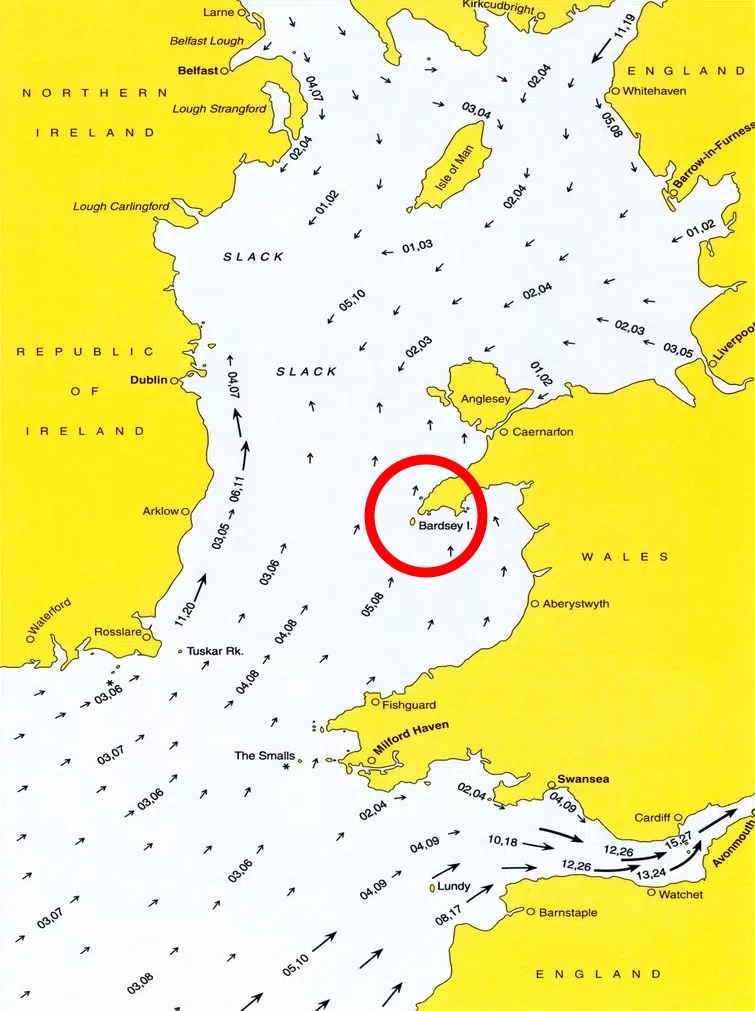
A tidal atlas chart of the Irish sea, the Bardsey area highlighted.
Mike from “Sailing cos I love it” includes some of this information in one of his recent videos, and you get to see the area in real-life not just on a chart: